
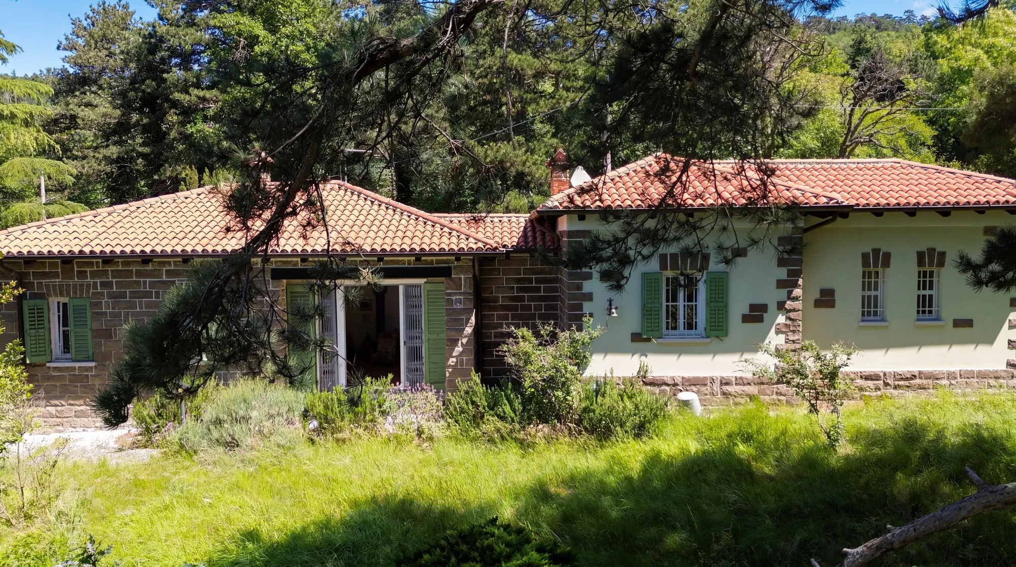
Small villa (multi-unit) with large park, sea view. Upper Via degli Olmi
Via Degli Olmi, Karst & Plateau, Trieste
€795,000
Small villa (multi-unit) with large park, sea view. Upper Via degli Olmi
Via Degli Olmi, Karst & Plateau, Trieste
The house in three numbers
94%
Of the land sees the sea
At eye level, measured every four metres on the Region's laser survey, with the city's buildings in front: from the Gulf of Trieste to the Istrian coast.
Counting the trees as solid walls too: 28%.
24,181 m²
Of land, in a single holding
Twenty-two plots of woodland, terraces, meadows, vegetable plots and vines, around a house of 150 m² (cadastral).
Land register and cadastre.
3 min
From SISSA and the International School
By car. Piazza Unità is 9 minutes away, the Obelisk and the Napoleonic Road a quarter of an hour on foot, the airport half an hour.
Routes on OpenStreetMap, in free-flowing traffic.
From the lawn, in a single take
The sea begins among the pines
Thirty seconds filmed on the land on 26 March 2025, without a cut: from the bench beneath the pines you move towards the light, and the gulf appears between the trunks. The drone flies at walking height; top left, the height it recorded, second by second.
Height above take-off point
1.2 m
Real drone footage, 26 March 2025, afternoon · No generative model: only light and colour corrected.
The real photo, the names calculated
Twenty-seven metres above the lawn
The drone rises above the treetops and the gulf opens up: the harbour, the Old Port, Muggia, the Istrian coast as far as Piran and Savudrija. We did not place the names by eye: the calculation projected them, from the position and height written in the photo's file. Switch on the calculated coastline: it is the line of the sea the calculation sees from here, and it matches the one in the photo.
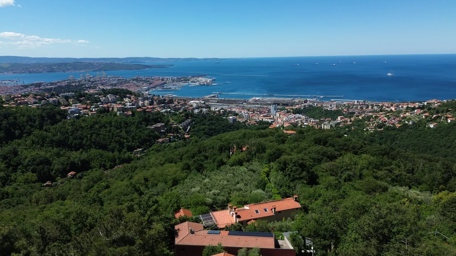 San Giusto 3.3 kmPunta Sottile 9.2 kmIzola 18 kmMolo Audace · Piazza Unità 2.9 kmLanterna lighthouse 3.7 kmPiran 23.5 kmSavudrija 30.7 kmOld Port 2.3 km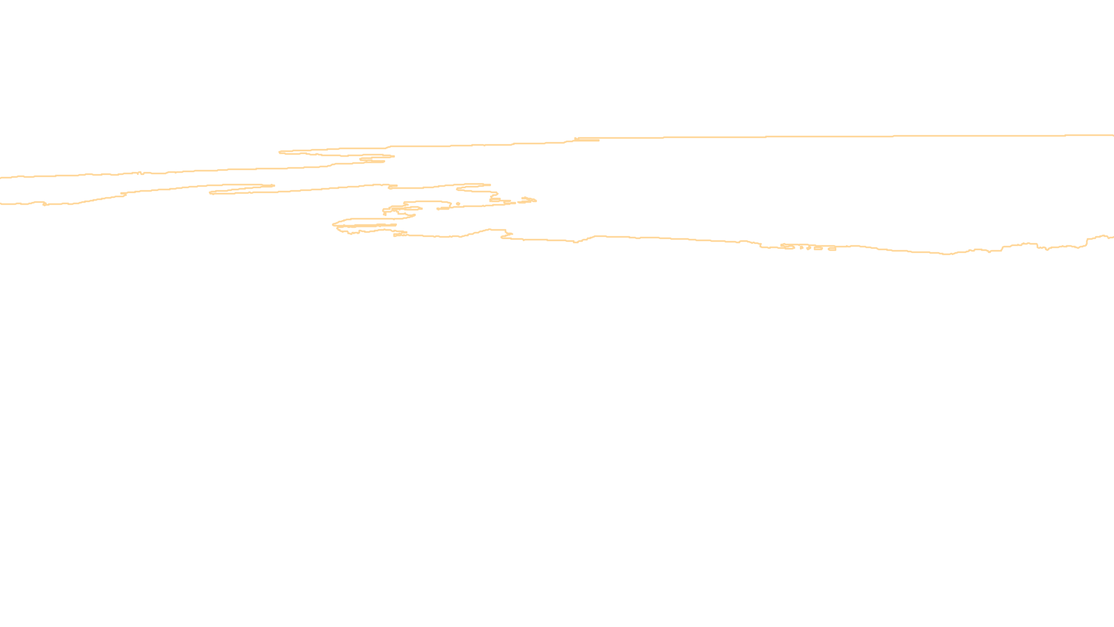
Real drone photo, 16 May 2025, 27 m above the take-off point on the lawn · unretouched
How it is made: position and height from the photo's file; direction, tilt and focal length found by matching the sea in the photo with the calculated sea. The resulting field of view, 69°, is the one stated for the drone's camera. A name appears only if, from there, the place rises above the line of the land and the buildings.
The sea, measured
The gulf is visible from 94% of the land
A photograph shows one spot at a time. Here the land has been measured spot by spot, every four metres, on the Region's laser survey and with the city's buildings in front: for each spot, how much of the horizon the sea fills. Choose where to stand. The panorama shows what you see from there at eye level, with the names of the places, and where the sun sets on the day you choose.
Preparing the panorama…
The land, point by point
- 94%
- of the land sees the sea at eye level, with the city's buildings in front
- 28%
- even counting every tree as a solid wall
- 129°
- of horizon filled by the sea at the most open spot
- 2.2 km
- from the sea, as the crow flies
How it is made. Land: digital terrain model from the laser survey of the Autonomous Region of Friuli Venezia Giulia (1 m and 10 m grids); beyond the regional borders, Terrarium elevation data. Buildings: heights from OpenStreetMap. Trees: canopy height map by Meta and World Resources Institute (2018). Boundary: the 22 cadastral plots (Italian Revenue Agency). Eye at 1.6 m above the ground, Earth's curvature and refraction included; a place is named on the panorama only if, from that spot, it rises above the line of the land. Sun: NOAA algorithm. Orthophoto: Region FVG, 2017-2020. It is a calculation, not a photograph: the visit remains the reference.
3D tour
Inside the house, room by room
The land and the house
Twenty-four thousand square metres around a house of one hundred and fifty
Twenty-two plots in a single holding: 24,181 m² according to the land register and the cadastre. Almost half is woodland, to the north and east; the rest is terraces, meadows, vegetable plots and vines to be brought back, on the slope that faces the sea. Below, to scale.
24,181 m²
the land
150 m²
the main house, cadastral area
The areas of the squares are proportional to the square metres. The land: 11,717 m² of woodland, 10,507 of vines, vegetable plots, meadow and pasture, 1,957 of buildings and yards.
In the green, close to everything
Two minutes from the Karst, nine from Piazza Unità
The house stands high up, between Cologna and Conconello, on the edge of the Karst: the Obelisk and the Napoleonic Road are a quarter of an hour on foot, SISSA and the International School three minutes by car, the centre less than ten, the airport half an hour, Ljubljana an hour. Every destination below sits in its true direction; the distance from the centre is the time by car.
The Karst
- Obelisk and Napoleonic Road2 min17 min on foot
- Grotta Gigante (Giant Cave)8 min
- Val Rosandra13 min
Schools and science
- SISSA3 min25 min on foot
- International School of Trieste4 min29 min on foot
- University of Trieste7 min
- Area Science Park8 min
- ICTP17 min
The city
- Central Station7 min
- Piazza Unità d'Italia9 min
The sea
- Barcola seafront11 min
- Miramare Castle18 min
Sport
- Golf Club Trieste8 min
Hospitals
- Ospedale Maggiore (hospital)10 min
- Cattinara Hospital11 min
Getting away
- Slovenian border (Fernetti)7 min
- Trieste Airport34 min
- Ljubljana1 h 05
- Ljubljana Airport1 h 17
- Venice Airport1 h 40
- Venice, Piazzale Roma1 h 48
Times calculated on 16 October 2026 on OpenStreetMap (OSRM, routing.openstreetmap.de) from the house, in free-flowing traffic: at rush hour allow a few minutes more. Walking times do not account for the climb.
Video
Property features
- Type
- Villa
- Surface
- 200 m²
- Rooms
- 5
- Bedrooms
- 2
- Bathrooms
- 2
- Floor
- On multiple levels
- Energy class
- G · 282.58 kWh/m² year
- Renewable index (EPgl,ren)
- 0.48 kWh/m² year
- Building envelope performance
- Winter: low · Summer: medium
›The full description
High above Trieste, on Via degli Olmi, a property looks down over the whole Gulf from the edge of the Karst — a few minutes from the centre, yet firmly out in the green.
Start with the land: 24,181 sq m of private grounds, reached easily by car, with parking that never runs out and the seclusion only a plot this size can give. The main house is a single-storey villa of roughly 150 sq m in excellent condition — two bedrooms and a small room used today as a third bedroom, two bathrooms, a sitting room with a majolica stove, and wide windows opening onto the sea-view garden beneath tall maritime pines.
A short walk away stand the old caretaker's house, built as a small rural cottage in 1938, with its stable and threshing yard: buildings to be recovered. Before any plans are made we will give you the full picture of their planning status, to be read with a surveyor or architect.
Commanding, private, wrapped in the Karst landscape, with city and sea held in a single view. For a buyer after space, greenery and potential — residential or hospitality — this delivers.
Energy performance. The certificate covers the main house, no. 33: energy class G, non-renewable global energy performance index (EPgl,nren) 282.58 kWh/m² a year, renewable index (EPgl,ren) 0.48 kWh/m² a year; building envelope performance low in winter and medium in summer. Heating and hot water come from a 2012 gas condensing boiler. Energy performance certificate valid until 16 October 2036.
Price €795,000.
Indicative taxes & costs
Purchase costs (one-off)
- TriesteVillas fee
- ≈ €31,800+ VAT
Annual running costs
- Property tax · ILIA
- Exempt (main home)
- Waste tax · TARI
- Occupants2≈ €315/yr
Annual costs are indicative estimates calculated with a formula from the cadastral data and the municipal rates, and do not replace an official check.
Floor plans
Browse the drawings; tap the plan to enlarge it.
Cadastral plan 11 of 9
Cadastral floor plan, with personal data removed: room names and heights are those of the document filed with the Land Registry (Catasto).
What the documents say
In the land registry the main building has three rooms, a small room and a laundry: of the four rooms counted in the listing, one is the small room. The outbuildings at number 35 are cellars and a former hayloft, that is, ancillary rooms.
A preliminary reading of the documents, made with the help of artificial intelligence by comparing the cadastral floor plan with the listing. What counts is the check we carry out with you, documents in hand, before any commitment.
Amenities
- To renovate
- Garden
- Detached
- Parking space
- Sea view
- Panoramic view
- Fireplace
- Barbecue
- Greenery view
- On the hill
Location
Approximate location within the area. The exact address is shared on request.
How we used AI in these photos
9 of 24 photos retouched with AI: 1 edited and 2 simulations, marked on the photo; 6 in light and colour only. The viewing remains the only reference.
How we edited them
The 24 photographs in this listing are shots of the property, from the ground and from a drone. 9 of the 24 went through a generative image model (Google's Nano Banana family, used through the Higgsfield platform); the other 15 did not go through artificial intelligence. Of the 9, 6 were retouched only for light and colour; in one the light and colour retouching changed the colour of the façade, which is pale green in reality and looks beige in the photo; 2 are simulations, which on the website carry the label «AI · simulated». In one drone shot the model drew at the top a sky with clouds and distant hills where the shot shows woodland, made the building on the right fully visible, although in the shot it is partly hidden by trees, adding flowering shrubs, and removed a sign and some objects from in front of the house door.
In another photo it added a terracotta pot in front of the wall, below the window. Where an object was removed, what it hid was not photographed: the model reconstructed it, plausibly; the same applies to the part of the building that the trees covered in the shot. Otherwise, according to the comparison with the shots, the houses, shapes, windows, stonework, land and garden are as photographed.
Even in the photos retouched only for light the model recalculated the whole image: the fine grain of surfaces is reconstructed, not photographed. Light and colour were corrected as in normal photo retouching. The original unmodified photographs are available on request; a viewing remains the only reference for the actual condition of the property.
How we use AI →Request a private viewing
Share two or three times that suit you: viewings are arranged around you.
Request information


Who answers
No call centre: you'll hear from the people who have actually seen this home. Same day, in English, Italian or German.
Buying from abroad? Read the buying guide →
Print sheet (PDF)See all villas for sale in Trieste →
Similar listings
Private Collection
Not quite the one?
Part of what we handle is never published: discreet owners, construction previews, private collaborations.
Access the Private Collection →